| Attributes | Values |
|---|
| type
| |
| comment
| - Spatial resolution (equivalent scale): 1:1500000
|
| dcat:contactPoint
| |
| dcat:keyword
| - Geologie
- Aquifer
- Groundwater
- Grundwasser
- Hydrogeologie
- Hydrogeology
- Petrographie
- Geology
- Lithologie
- Rasterdaten
- Geodaten
- Geoinformationssystem
- Karte
- Produktivität
- Quelle
- Wasser
- Wasserwirtschaftliche Anlage
- Norwegen
- Schweden
- Dänemark
|
| dcat:landingPage
| |
| dcat:theme
| |
| dcat:distribution
| |
| Title
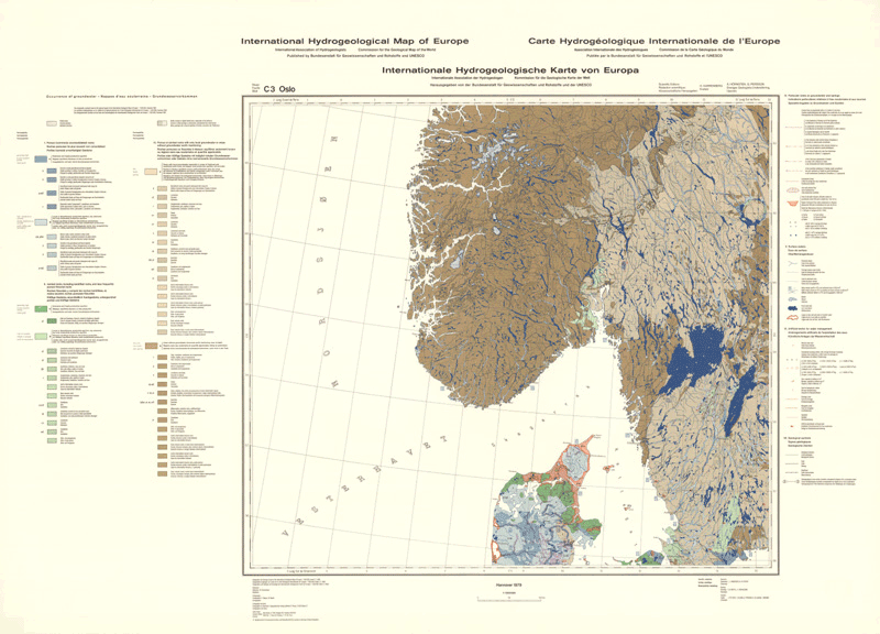
| - Internationale Hydrogeologische Karte von Europa 1:1.500.000 (IHME1500) - Blatt C3 Oslo
- International hydrogeological map of Europe 1:1,500,000 (IHME1500) - Sheet C3 Oslo
|
| Description
| - The International Hydrogeological Map of Europe, scale 1:1,500,000 is a series of general hydrogeological maps comprising 25 map sheets with explanatory notes, covering the whole European continent and parts of the Near East. The national contributions to this map series were compiled by hydrogeologists and experts in related sciences of the countries concerned under the auspices of the International Association of Hydrogeologists (IAH) and its Commission on Hydrogeological Maps (COHYM). The project is supported by the Commission for the Geological Map of the World (CGMW).The scientific editorial work is supported financially by the Government of the Federal Republic of Germany through the Bundesanstalt für Geowissenschaften und Rohstoffe (BGR) and by the United Nations Educational, Scientific and Cultural Organization (UNESCO). These organizations are responsible for the cartography, printing and publication of the map sheets and explanatory notes.The series of hydrogeological maps seeks to represent the hydrogeological setting of Europe as a whole without regard to political boundaries. Together with the information presented in the accompanying explanatory notes, the map can be used for scientific purposes, for large-scale regional planning and as a basis for detailed hydrogeological mapping.
- Die Internationale Hydrogeologische Karte von Europa im Maßstab 1:1.500.000 (IHME1500) ist ein Kartenwerk hydrogeologischer Übersichtskarten, das aus 25 Kartenblättern mit dazugehörigen Erläuterungen besteht und das den gesamten europäischen Kontinent und Teile des Nahen Ostens abdeckt. Die nationalen Beiträge zu diesem Kartenwerk werden von Hydrogeologen und Spezialisten anderer verwandter Wissenschaftsbereiche unter der Schirmherrschaft der Internationalen Assoziation der Hydrogeologen (IAH) und ihrer Kommission für Hydrogeologische Karten (COHYM) geleistet. Das Kartenprojekt wird von der Kommission für die Geologische Weltkarte (CGMW) unterstützt. Die wissenschaftlich-redaktionelle Arbeit wird finanziell durch die Regierung der Bundesrepublik Deutschland über die Bundesanstalt für Geowissenschaften und Rohstoffe (BGR) und die Organisation der Vereinten Nationen für Bildung, Wissenschaft und Kultur (UNESCO) gesponsert. Beide Organisationen sind für die Kartographie, den Druck und die Publikation der Kartenblätter und Erläuterungen verantwortlich. In der IHME1500 werden die hydrogeologischen Gegebenheiten von Europa als Ganzes ohne Berücksichtigung politischer Grenzen dargestellt. Gemeinsam mit den begleitenden Erläuterungsheften kann das Kartenwerk für wissenschaftliche Zielstellungen, für regionale Planungen und als Grundlage für detaillierte hydrogeologische Kartierarbeiten genutzt werden.
|
| Identifier
| - F4574B9F-22DE-4B17-9E12-25B89606069A
|
| Language
| |
| Relation
| |
| Type
| |
| page
| |
| Date Issued
| |
| Subject
| |
| Spatial Coverage
| |
| Access Rights
| |
| Provenance
| |
| is primary topic of
| |
| is dcat:dataset
of | |
| is primary topic
of | |


![[RDF Data]](/fct/images/sw-rdf-blue.png)

![[cxml]](/fct/images/cxml_doc.png)
![[csv]](/fct/images/csv_doc.png)
![[text]](/fct/images/ntriples_doc.png)
![[turtle]](/fct/images/n3turtle_doc.png)
![[ld+json]](/fct/images/jsonld_doc.png)
![[rdf+json]](/fct/images/json_doc.png)
![[rdf+xml]](/fct/images/xml_doc.png)
![[atom+xml]](/fct/images/atom_doc.png)
![[html]](/fct/images/html_doc.png)